Saturday, January 31, 2009

Speed & Angels, Tonight 7:30 PM, Lobero Theatre

I like to try and post about the trails on this blog but there is an event happening tonight worth breaking that rule. The event is a screening of the movie Speed & Angels, part of the SBIFF, at the Lobero Theatre. I was lucky enough to be given a copy of this movie about a year ago by a relative of the director. Before I saw the movie I was told it was about Navy pilots trying to qualify for service on carriers around the world. Not knowing anything else about the movie, I popped it in the player and watched it. Thinking I was going to see some top gun knockoff I was pleasantly surprised it was not. I can best describe it as Top Gun minus the cheese.

The story follows two pilots, a female, Meagan, and male, Jay both just out of flight school. I won't give away too many details away but the film focuses on who these people are inside the planes as much as they are out. Amazing cinematography, unlike anything you've seen before and well a rounded story, entertaining for people who know nothing about jet fighters to jet pilots themselves.

The screening is tonight at the Lobero, 7:30 PM and both pilots will be flying in to attend for a Q&A following the film. SBIFF website: http://www.independent.com/movies/498/

Friday, January 30, 2009

Gibralter Road and Other Road Closures

From the County of SB-

Good day and I hope everyone is doing well—

My name is Matt Dobberteen and I work for S.B. County Public Works.

I am writing to alert you of South Coast Road Closures currently in effect.

GIBRALTER ROAD

Gibralter Road is closed from West Mountain Drive through East Camino Cielo to Painted Cave .

This is due to a combination of extremely rough pavement and unstable slopes, particularly in the burn areas from our recent fire. A combination of debris coming off these slopes into the roadway and very rough pavement creates hazardous conditions for anyone who attempts to use this road.

For your own safety please stay off this Gibralter Road .

We will notify you when the road reopens for use. Our best estimate for lifting the “Closure” will be some time this summer. This is due to the time it will take to complete the necessary repairs and to allow the slopes to stabilize to an acceptable condition. We thank you in advance for your cooperation.

EAST CAMINO CIELO

East Camino Cielo is closed from Painted Cave Road to Gibraltar Road .

This is due to extremely rough pavement which creates hazardous conditions for anyone who attempts to use this road.

For your own safety please stay off East Camino Cielo.

We are attempting to complete repairs in February 2009 and will notify you when the road reopens for use. We thank you in advance for your cooperation.

If you have any questions, please write at this email address or call at 568-3576. RIDE SAFE!

Take Care-- Matt Dobberteen

Wednesday, January 28, 2009

Trail Maintenance- Our New Proposal

If you've been on the trails lately you may have noticed that things are startin' to grow. Winter weather and high usage are puttin' the trails in a state of disrepair. Over the years several trail organizations have led the way in repairing our trails but there are many miles of trail and there have not been enough people to go around.

We proposed this week to the Task Force a new idea in trail maintenance. With our FCTC, three organizations are available to care for the trails. Instead of the regular organized trail events, divide the trails amongst the 3 groups and let them care for them as needed. This plan would be for the SB trails since the MTF is in charge of maintenance in Montecito.

Trail care begins with the little things. The waterbars which direct water off the trail are essential in preventing erosion and damaging trail tread. The waterbars on Jesusita(MC side) hadn't been cleared in probably the last 3 years. Being sick of seeing the huge rut forming in the middle of Jes. every winter for the last couple years, I decided to clear them out myself. Simple tasks like this and brush work and fixing minor damage increase safety and prevent doing major repairs down the road. Our thought is that we need a better trail maintenance plan working before any large scale trail rehab can be done. Otherwise, why do trail rehab if we won't be able to maintain what we've done.

Also on the trail maintenance front, two ultra running races are going to be held in the SB back country over the summer. We have contacted the race directors and let them know we are available for helping out. More on this as it develops. For more on these races visit: http://www.trailrunnermag.com/news_detail.php?id=158

Monday, January 26, 2009

Parma Park Showing Signs Of Life...and Other Pics

First time I rode on Mountain Drive since before the Tea Fire. Partially out of respect of the victims and partially to the fact that its not the same any more. This past Sunday I rode Mt and found far more bikes than cars on this nearly deserted street. The photo taken of Parma shows grasses pushing through after the last couple of rains. It is a good thing Parma is closed because also visible are several areas of hillsides sliding down and taking sections of trail with it. Below this photo is one of Parma taken the week after the Tea Fire. Below both of them is a photo from my afternoon run up to Inspiration Pt.

Parma 1/25/09

Parma 11/18/08

Inspiration Point 1/25/09


Sunday, January 25, 2009

We've Changed Our Name!

Yes you heard correct, our domain name has changed. When we started our website the name we wanted was not available, it recently became available and we grabbed it. The new address is: MULTIUSE.ORG
The former domain is still active and forwards to the same site but the new one is much easier to remember. Email will remain the same but new emails with @multiuse.org will be listed on the contact of our website. Pass it on.

Tuesday, January 20, 2009

New Trail For Goleta Being Proposed?

We've all seen it, that clear cut strip of land near 154 that runs from Camino Cielo down to the foothills. It was dozed in July during the Gap Fire to create a fire break but luckily the fire didn't make it that far. What many people do not realize is that fire break was constructed exactly where a trail used to run above Goleta. The old maps show it(see below) and now that its open again....why not?! Jeff Harbison had that same thought and contacted the MTC before submitting a proposal to the USFS about creating a new/old trail. Hopefully this fire break will turn disaster into opportunity at some point in the future.
The problem that may exist with moving forward is that there appears to be private land blocking a complete trail. As we have seen with other new trail projects these things take time, the Franklin Trail is still having problems getting opened after 3+ years of action. Some logical ending points for this trail may be the San Marcos Foothills Preserve- does anyone know if this us under development? San Antonio Creek Open Space/Tuckers Grove could be another option as is connecting over to Arroyo Burro. More updates on this as it is discussed at future meetings......


View of the unnamed trail(Gap Trail?) from SMF Preserve
Elevation Profile of the trail

Map of the trail with GPS Waypoints


Dozing "it" for the Gap Fire(taken 7/08)

Doh! Just when you thought you were on your way

Ample parking at one possible trail head(SMF Preserve)

Thursday, January 15, 2009

The Race Is On

Every time I see this race I can't stop laughing. I love to show it to my married friends to watch thier reactions- they go from laughing to crying in the time it takes to watch this.


Tuesday, January 13, 2009

Cort Goes For Big Air On Tunnel And Lands It!

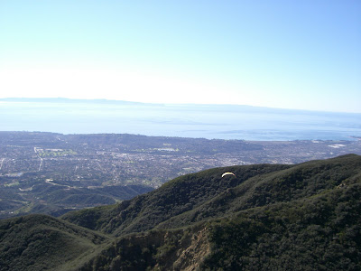
The Multiuse Trails Coalition congratulates Cort Flinchbaugh who pulled off some aerial acrobatics this past weekend . Cort soloed for the first time off Gibralter Rd. only to make a perfect landing near the 154. He tells us the experience is unbelievable and will be doing a lot more in the future. See the photos below and see if you can I.D. where he is.


Sunday, January 11, 2009

USFS Trail Surveys In Progress Now!

Over the next year the USFS will be conducting surveys on our local trails and campgrounds. This process is done about every five years and is concurrently being done in the Los Padres, San Bernadino, and Cleveland National Forests. This weekend the survey was being conducted on Romero Trail where the surveyor sat all day asking hikers and bikers to participate. An electronic counter is at the trail head to count trail use also. The survey only takes a few minutes so please stop by and take the survey, this information will be used by planners for allocation of funds and to determine trends of recreation users.

* Note the information collected in this survey will not be used for our Front Country access planning, the Task Force is responsible for this task.


Hikers Taking the Survey

Trail Use Counter
The Survey

Friday, January 9, 2009

Proposed Mtn Biking Rule Changes In Your National Park System

Dear Trail User,

We reported on our blog in Oct of 2008 that President Bush was considering easing restrictions on mountain biking in the national parks. In late December he did just that and has written a proposed rule change that would allow park managers of approximately 30 national parks to decide what trails would be acceptable for use of mountain bikes. Currently bicycles may only ride on paved roads in most national parks.

We are in strong support of bicycling on trails in the National Park System that park managers decide are suitable for multiple use travel. We feel the time has come to move into the future as we hope you do. The decision is not final and public comment will help determine the outcome of this proposal. Yes, we said public comment. The public comment period will only be open until 2/17/09 so please act accordingly, the online comment form only takes 2 min to complete! We will link below forms to comment on the rule change, to look at the proposed changes click HERE.

To comment on this proposed rule click here for the official government website or here for the IMBA site comment form(better yet do both!) Your voice will make a difference in this decision process, if you don't think so check here and here to see what comments are being left on the subject.

The Multiuse Trails Coalition

Tuesday, January 6, 2009

Got Information on Gaviota Coast Trails and Bike Paths?

We received this email from Mariah Moon of the Naples Coalition, please contact her if you can help out:

I am a volunteer with the Naples Coalition and am researching trail use on the Naples property(located 2 miles north of the Winchester Canyon fwy exit), the eastern gateway to the Gaviota Coast. We are trying to show that people have been using the trails for quite a while and are trying to document this use in order to preserve public use of the trails and public access to the beach.
I wondered if you have any information about trails used by bikers in this area and if there are there known coastal routes that link Goleta to El Capitan/Refugio via a dirt trail? Also, do you know of any printed maps, published or not, that may show this area as a route for bikers or anyone else?
Thank you very much for any information you might have.
Happy trails,
Mariah Moon, Naples outreach comittee 805-451-3071, aquamoon42@hotmail.com
Details on our mission to save the beach access trails and bluffs of Naples are at savenaples.org and gaviotaaction.org

Sunday, January 4, 2009

Finally A Good Way To Stay Warm On Your Rides or Hikes!

It's functional, it's fashionable, it's Snuggie! Won't get caught in your derailleur and will keep the poison oak off your legs on the trail.