Thursday, May 28, 2009

June 13th- Jesusita Fire Trails Restoration- National Trails Day

The trails need your help! On Saturday, June 13th the agencies and most local trail organizations including ourselves will be involved in repairing the trails effected by the Jesusita Fire. Trails to be repaired June 13th include: Jesusita, Tunnel, Rattlesnake, and West Fork of Cold Springs. There is still a lot of work to be done in order to re-open these trails- you can make a difference! We will meet at Skofield Park and most likely have a BBQ following. Tell a friend and check our homepage for more details about this event.

One of Many Areas on Tunnel That Still Needs Help

Sunday, May 24, 2009

Tunnel Trail Restoration Re-Cap

Our first trail maintenance project following the Jesusita Fire this past Saturday was a success. We were asked by the USFS to help out with the restoration of Tunnel Trail which needed a lot of work. Six lucky volunteers took the task of removing a ton of shale, debris, and ash from the lower section of Tunnel Trail. It was very hard work and the team worked hard, but in the end the trail tread became visible again and measures to ensure it stayed that way hopefully will last. Also on hand were the LPNF Hot Shots who tackled the upper section of Tunnel. Tunnel is very much on the way to coming back to life especially with thanks to the hard work of: Carolyn P, Joani M, Chris O, Pete L, and Chris K. -Dave for the MTC

Scraping The Trail Clean
That's Why We Had Dust Masks
Piles Of Rubble
Carolyn Hard At Work
The LPNF Hot Shots
Deep Trail Ash
The Crew

Friday, May 22, 2009

The Sad State of Tunnel Trail

In preparation for our trail restoration project tomorrow, I was able to hike a little bit on Tunnel Trail to see what was needed to be done. Just a month and a half earlier, we had done work on Tunnel, trimming brush, opening water bars and restoring tread. During that process I snapped some photos of the work we did, before and after. Now sadly I can compare those photos to the condition it is in following the Jesusita Fire. We will be heading out on the trail several times a month to repair damage done by the fire. Contact us if you would like to find out how you can help: multiusetc@gmail.com


Tunnel Trail Head - Late March
Tunnel Trail Head Post Jesusita Fire
Tunnel Trail Water Bar 4/09
Tunnel Trail Water Bar Post Jesusita Fire
Jesusita Trail Head 3/09
Jesusita Trail Head Post Jesusita Fire

Lower Tunnel Trail Post J.F.

Upper Tunnel Trail Post J.F.

Tunnel Trail Waterfall Post J.F.


Wednesday, May 20, 2009

Jesusita Fire Trail Restoration Projects and Updated Trail Closures

The USFS today lifted all forest closures due to the Jesusita Fire. Although the forest is open most trail closures remain in effect. Jesusita, Rattlesnake, and Tunnel will remain closed as will West Fork Cold Springs. Cold Springs Main Trail and those trails to the east of it are now open according to local agencies.

Our Front Country Trail Crew will be hosting trail restoration projects over the next several weeks to expedite the opening of the remaining closed trails. When the trails become safe to use again the agencies will open them for public use. We have two projects scheduled on 5/23 and 5/26 for the Tunnel Trail Area. Visit our volunteer page to find out how you can help get the trails restored and open to the public. Thank You, The Multiuse Trails Coalition

Sunday, May 17, 2009

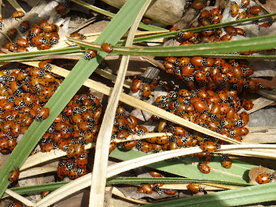
Coccinellidae Return To Romero

Seems like Romero Canyon Trail has become a breeding ground for Coccinellidae A.K.A. Ladybugs. They will be appearing daily for the next several weeks at all the creek crossings.

Tree Huggers

Friday, May 15, 2009

The Good News About The Trails Is......

The good news is that trails are open east of Cold Springs including: Hot Springs, San Ysidro, and Romero. The bad news is that I drove up to the other trail heads to check their status and posted their photos below. Jesusita off of San Roque and Tunnel Trail head both got torched. When they open again at some point be prepared for complete shock. Tunnel Road is down right depressing. Many power poles have been burned and are under repair, vegetation on both sides is gone. Familiar houses that have made the Tunnel Rd area unique are now piles of rubble. The trail head itself must have been an inferno. Metal signs on both sides of the trail head are disfigured and close to the melting point. The gate at the trail head which used to contain our advertisement for our "happy hour" now has melted plastic where it used to be. The landscape is unreal, it looks more like a desert than a trail in Santa Barbara and the ground around the trail head itself is still radiating heat. It will be some time before these areas look the way we are used to seeing them. We will be helping the agencies to get our trails back to usable condition again. If you would like to be part of this process contact us for further information. Dave for the MTC


Cold Springs- Closed
Rattlesnake- Closed
Tunnel Trail Head- Closed
Tunnel-Photo Taken 1 Month Ago
Tunnel Trail Head Area
Tunnel Singed Signs

Jesusita Trail Head- Closed (that post used to be the trail head sign)

Jesusita Trail in San Roque Canyon

Stevens Park Jesusita Trail Access- Closed

Thursday, May 14, 2009

Inspiration Point Montage

Thanks to an idea by Rob R., I have put together a series of photos of the Inspiration Point area. These photos were taken from the same Riviera location during and after the Jesusita Fire. Dave


Wednesday 5/6 am, appeared calm and somewhat under control
Wednesday 5/6 pm, it was definitely heading towards the Riviera
Friday 5/8
Thursday 5/14, The Aftermath

Tuesday, May 12, 2009

Romero Canyon Gets Dozed


As soon as I got the press release that some of the Front Country Trails might be open, I got out there. I haven't been on any of the FCT'S in over a week and a half and was starting to go through withdrawals. I headed out to Romero to do the 5.5 mile loop run and I thought maybe I had heard wrong when I pulled up to the trail head. There were three large semis almost blocking the road and a half dozen other fire fighting vehicles nearby. The Cal Fire guy waved me through and I asked if the trail was open. He told me yes, they had just finished and apologized that they may have ruined the fire road by plowing it. I told him not even a problem and thanks for all the hard work. Anything that is going to make the fire fight a little easier I am all for even though it may slightly change the landscape.

Heading up the fire road it was really powdered. Much more powdered than the last time it got plowed and much wider this time too. In fact it was almost wide enough for two cars to pass each other in some places. It is definitely still a 4x4 road but much smoother than the last time they plowed during the Zaca Fire. As I headed up the canyon trail it looked the same. It was the same until one spot about 1/2 mile from the cross-roads where rocks and debris from above have covered the trail. I cleared a bit of the smaller stuff away but a boulder the size of a desk is still on the trail. Other than that, the trail is virtually the same up to the fire road.

On the way down the road I could hear the dozers at the very top near Camino Cielo working. From what I could tell nobody had even been up there yet on bike or foot. As I headed down I ran into a few other hikers and cyclists trying this new road out. It will be some time before it is back to a hard packed tread again. After getting home I spoke with local ranger Kerry Kellogg who told me for the first time since the 1970's he drove the Romero Road again today. I was happy to have this trail back especially after seeing photos of Tunnel and Rattlesnake Trails in the Indy and the damage they sustained. Both these trails are going to need extensive repairs in the near future to become usable again. Dave


Parking Area?


The New Trail Head Masticator

Romero Canyon Trail Debris

More Debris

The Newly Widened Cross-Roads

Romero Highway

Another Happy Trail User- Note This Area Had Large Rock Slide Damage Before Last Week

USFS ANNOUNCES FRONT COUNTRY TRAIL CLOSURES

The USFS in a press release today updated the forest closures due the the Jesusita Fire. All Front Country Trails between Refugio Rd. and Cold Springs Canyon will remain closed. Trails east of Cold Springs including Hot Springs, San Ysidro, and Romero are open. Read the full press release with other information here and the map here.

Saturday, May 9, 2009

Updated Jesusita Fire Perimeter Maps for 5/9/9

5/10/09 Inciweb now has updated info and maps of the fire: http://www.inciweb.org/incident/1640/

We have the updated fire perimeters from Google Earth and Geomac Viewer. The Google Earth map, made using Modis satellite images shows locations of front country trails(except for tunnel). The Geomac satellite image from 5/8 shows a more accurate location of the burn along with Gap and Tea Fire perimeters.


Google Earth- The red spots indicate newer burn areas where other colors represent older
Geomac- taken 5/8/09

Friday, May 8, 2009

Jesusita Fire Perimeter Map for 5/8/9


We had been unable to find a good perimeter map for the fire so we used Google Earth and a current Modis satellite photo to create one. Trails are listed but unnamed, West Fork of Cold Springs is not shown but would be in the "red" zone by Gibraltar Rd.

Wednesday, May 6, 2009

Inspiration Point

Here is a photo from the Riviera of Inspiration Point and the surrounding area. The Jesusita Fire appears to have burned Jesusita on both sides of Inspiration Point and the Point itself. From the location on the Riviera it was impossible to see where the fire was in the canyon itself. For some pretty cool Google Earth overlays of the fire click here and scroll down to the active fire maps.


Tuesday, May 5, 2009

Jesusita Fire

We had scheduled to do trail maintenance on Jesusita this afternoon until this fire broke out. I helped friends who live on Los Canoas prepare to leave by squirting down the house and cutting brush that was very close to the roof. From their house below the Botanic Gardens I was able to snap the photo below. I believe the clump of trees to be Inspiration Point and the fire appeared to be behind it moving west to east. This evening from downtown the fire looked to be spread out in several different directions in the Tunnel/Jesusita area. We will post updates on the trail closures as we hear them from the Task Force. Dave