
Tuesday, June 26, 2018
Friday, May 25, 2018
Thomas Fire Closure Lifted
With the closure being lifted there are a few things to keep in mind before heading onto the trail:
Safety - Trail conditions range from in need of basic maintenance to life threatening. There are segments of trail which are untouched and appear nearly as they did before however most trails have segments with missing portions, boulders blocking, down trees, loose sediment, or at risk for more rock or tree fall. That being said, the Forest Service will be placing warning signs on the trails to inform users of these dangers. In addition to this, large scale restoration projects are soon to begin on both open and closed trails. The safest trail user is one who stays out of the burn area completely or uses the SCE fire roads which have all been rebuilt
Respect - It is essential that trail users respect their surroundings including neighbors who are going through unimaginable losses and do not need to worry about parking difficulties or other matters related to trail use. It is also important to understand the conditions of the hillsides around the trails as they are very fragile and will take years to regain their former glory so please stay on designated trails.
Map of the trail status as of 5/24/18, Red = closed, Green = open

Friday, April 13, 2018

Thursday, February 1, 2018
Helping Montecito Homeowners Dig Out!
MESSAGE FROM THE SANTA BARBARA BUCKET BRIGADE:
Hi everybody!
We will be working all this week and
this weekend to help get these flooded homes cleared out!
Tomorrow, 2/1 and Friday,
2/2, interested volunteers should come to the volunteer
table at 145 Santo Tomas at 9:00am .
Volunteers able to work on Saturday and/or Sunday should come to the volunteer
table at Lower Manning Park
Saturday
February 3rd, from 9:00-3:00
Sunday
February 4th, from 8:00 - 1:30
Please RSVP to this
email address with the days you are planning to be of service.
Whenever you are able to come, sign in,
get a mask and gloves, and we will go to job sites from there.
IMPORTANT:
We are working in potentially toxic mud and debris. It is crucial that you come
dressed wearing: work pants (no yoga pants!), a long-sleeved shirt, work boots
or muck boots, gloves and masks (we have gloves and masks available if you need
them). Please bring a shovel and a wheelbarrow if you have them.
Thanks for your continued support!
Leadership Team
Santa Barbara Bucket Brigade 2018
email: teafirerelief@gmail.com
email: teafirerelief@gmail.com
Sunday, January 28, 2018
Thomas Fire Trail Closures Extended by County of Santa Barbara
County Closure Sign at Franklin Trail Head

With road access now allowing people into most areas of Montecito following the tragic mudslides, here is what you need to know about the status of your favorite trails along the Front Country.
*UPDATE: 2/1/18 The County of Santa Barbara has re-opened it's portion of the Franklin Trail, please note the FS closure is still in effect for this trail! The county will monitor conditions and further closures are possible on this trail again throughout the winter.
Monday, January 8, 2018
Thomas Fire Front Country Trail Closures Demystified
The Thomas Fire has effected every one from our local communities in one way or another. From the devastation seen through entire neighborhoods to the loss of life, it is was an event that shall not be forgotten any time soon. The smell of smoke when one ventures nears the burn zone and those fiery images will be engrained in all of our memories for a long time to come. Our condolences go out to anyone effected by this fire.
And then there was the mass destruction to the vegetation on hills and mountains between Santa Paula and Santa Barbara. The Los Padres National Forest has never seen anything of this size or this amount of destruction before. Trails and roads across the entire forest have been compromised and will continue to be unsafe especially with loose hillsides that will fell rock and debris after every rainstorm. The recovery will take years as we have seen with the much less severe Jesusita Fire, but eventually things will return level of normalcy. Then there is the high potential for flooding across areas where the watersheds were stripped of growth......
When will the trails re-open?
The good news is that all Front Country Trails West of Gibraltar Road have re-opened, however those to the east of Gibraltar Rd. including Franklin Trail have been closed off if not in their entirety, to a significant degree. The Forest Service Closure Order and Map outlines these closures, which states that within the National Forest, in areas that were effected by the Thomas Fire are now closed. Further clarified, certain trails have trail heads which begin outside the forest and then enter and are closed at the entry point. Official trail closure signage has now been placed at all trail heads indicating "closed" or "closed ahead" with additional closure signage at the forest boundary line, and the FS has begun routine patrols of these areas. Those trails effected by this closure order are Cold Spring, Hot Springs, Mcmenemy, San Ysidro, Buena Vista, Old Pueblo, Girard, Saddle Rock, Romero, and Franklin Trails. Cold Spring(Main entrance) and Romero begin within the National Forest and are closed off in their entirety, however some other trails the distance between the trail head and NF boundary can vary from a few feet to as much as 3/4 of a mile as in the case of Franklin Trail. The county of Santa Barbara is aware of this and considering further closures to narrow the gap. This photo album with maps of effected trails highlights trails along the front country and where they close/cross into National Forest Land.
As to when the trails east of Gibraltar Road will re-open, no firm date was given by District Ranger Smith, only that it would be after the rainy season has ended and the trails have been evaluated for safety.
Is there a trail you were wondering has re-opened and didn't see it listed here, contact the local ranger station to find out as trail status in some areas this may change throughout the winter: (805) 967-3481
How can you help?
First and foremost, stay off the trails that have been closed to public access and resist the urge to visit areas where water/debris flow is likely to be high during and after rain storms. As for trail maintenance projects, none are permitted at this time by any local organizations on Forest Service lands within the closure and the only assistance the FS has asked of local groups is to help place closure signs and notices and help get the word out to trail users as to the trail status. Some consulting on terrain across the front country has also been asked of local groups and trail maintenance projects will continue on OPEN trails throughout the winter as storms wreak havoc. Contact one of many local trails organizations for any events planned on OPEN trails, not only on the Front Country but throughout the LPNF. The FS is in the process of bringing in specialized trail crews to help divert water from trails thus preventing mass erosion on trails effected by the Thomas Fire.
P.S. The FS let trail organizations know they are monitoring Facebook and aware of the trespassing/posting of photos on closed trails!
Sunday, December 31, 2017
Thomas Fire Closures on the Front Country have been reduced - See map and order below for details
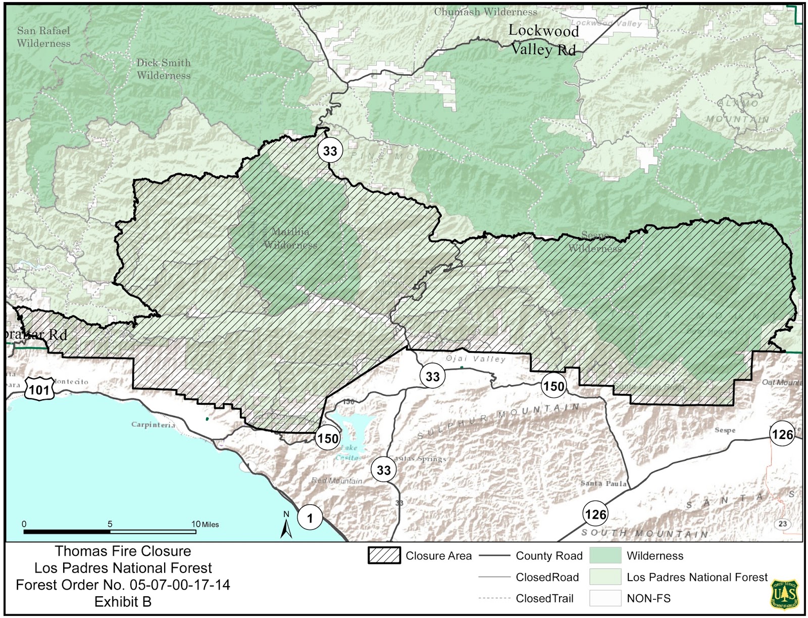
The 12/19/17 Map indicates all trails west of Gibraltar have reopened
Subscribe to:
Posts (Atom)