Wednesday, December 31, 2008

Second Hiker Injured in the Last Two Days- Be Careful Out There People!

From the News Press:

SANTA BARBARA- A man who broke his ankle while hiking near Stevens Park had to be carried out by Santa Barbara fire crews Tuesday morning. The unidentified 62-year-old was located about a half-mile north of the park, near the Jesusita Trailhead, off San Roque Road. A fellow hiker reported the incident about 8:30 a.m. after walking back to his home on nearby Foothill Road. Crews had to hike in to tend to the victim.

Visit our homepage for safety tips on hiking!

Tuesday, December 30, 2008

Hiker Injured On Rattlesnake Canyon Trail

An experienced hiker fell and was injured while hiking in Rattlesnake Canyon Monday. The accident happened in the early afternoon approximately 1 mile from the trail head(see photo). The hiker who was alone at the time, recieved assistance from two hikers on the trail that heard his yells. The two hikers called 911 and helped the injured man by getting him into some dry clothes and applying pressure to help stop bleeding. County Fire flew in and air lifted the man out to be taken to Cottage Hospital. His injuries were a broken wrist, a shattered vertebrae in the low back and head lacerations. The exact location and or trail is unknown but the victim says that it was a narrow portion that just gave out. We have hiked the main trail and found it to be intact up to the meadow but there are numerous trails that run along the creek that also get high usage. The hiker is local and a frequent trail user and we wish him a speedy recovery and hope he is able to get back on the trail soon.(Photo Courtesy of M. Bacon)


Sunday, December 28, 2008

Thursday, December 25, 2008

Monday, December 22, 2008

Bye Bye Billy Goats

They came, they saw, they ate...everything. After several weeks on Tunnel Trail the goats have moved on to greener pastures. Set up as a test program by the Mission Canyon Homeowners Association and the County of SB, the goats seemed to have hit the mark. There is a noticeable decrease in the amount of brush on both sides of the trail the hope being that this will reduce the chance of fire in the MC area. The goats, who have been in various MC locations since October of this year are still around just in less noticeable areas. Hopefully this catches on and other parts of SB use the goats too.

The Website: http://www.brushgoats4hire.com/

Saturday, December 20, 2008

Stuck All Day In The Board Room Friday

Luckily the board was my snowboard and the room was the secret mountain at an undisclosed location that got another foot of powder since my last visit. Even with my 30" snowshoes I was sinking in about a foot for every step I took due to the light snow density. At this point the mountain had excellent coverage and no longer did obstacles stick out from the snow. I had the mountain all to myself in the AM, heading up and down the 1000' elevation gain 2 times before I was joined by Rob in the afternoon. Something about having to get to the top on your own or maybe the natural terrain make backcountry funner than riding up on a chair. Here are some photos from the days events.

My Chair Lift
Self Portrait
My Boardroom
Penthouse View
Antelope Valley
Me
Leaving My Mark
Natural Terrain

Fun Features of the Boardroom
Me
You Should Have Been There
Rob

Wednesday, December 17, 2008

Who Needs A Ski Lift?

Location: Secret, Gear: Snowboard, Snowshoes, Conditions: 2 feet of powder, 30 deg and dropping, Date: Dec 16th 2008.

Due to global warming I haven't been back to this Southern CA secret spot in the last 4 years. There are no lifts, not many other people and no shortage of bitchin'. Here is the photographic account from the days events.

The Mountain
The Terrain
This guy Jim who also had the same idea.
More Terrain

Me

Snow

Depth Gauge
Fresh Tracks

More Fresh Tracks


Sunday, December 7, 2008

Rattlesnake Canyon Trail Re-Opened This Weekend

Three weeks after the lower part of Rattlesnake burnt, the City has reopened it. First thing you notice about it is how open it is with all the brush gone. The fire charred both sides of the trail up until the Gibralter Road entrance. From that point it stayed just to the east side of the trail just past the second creek crossing where it burnt away from the canyon and towards the circular house. The trail is in good condition and City Parks reminded us that they would like people to stay on the trail to help preserve delicate hillsides.

Just after the T.H.

The trail was the fire line here
Second creek crossing
Hillside above the second creek x-ing

Names Of The Tea House Fire Starters

This seems to be what everyone is talking about, whether or not to release their names. If they charge them with a crime then it seems appropriate but waiting to release info seems to be angering people I have spoken to. A friend who lost his house and did not have a chance to pack a single thing told me he hopes they release the names. I came across this article of another accidental fire starter who was just sentenced:

http://cbs5.com/local/yosemite.fire.jail.2.880804.html

He burnt down 30 homes and 34,000 acres and was sentenced to probation and 541$ fine. The sentence for the 10 will probably be along those same lines if they are charged.

Tuesday, December 2, 2008

Task Force Recommendations Progress Report

As reported earlier new kiosks will be going up on all the trails in town. Soon to follow are the informational/interpretive signs for these kiosks. This first kiosk was spotted on Tunnel near the fire road.

Saturday, November 29, 2008

Ladybug Redux

Romero Canyon today where the ladybug invasion is still on.


Monday, November 24, 2008

Cold Springs Trail Open....Again.

We just spoke with County Parks who told us that the press release saying CS trail was closed, was a mistake. They said they never closed Cold Springs although there may be some lingering smoke on the trail.

Sunday, November 23, 2008

Mountain Drive Flood Prevention Day Photos

Probably the best thing that I have done all week or maybe even all month was help with the MDCA flood prevention today, 11/23/08. At least a hundred people were all volunteering to prevent what could be horrible mudslides for anyone living below the burn area. It was a well organized event where groups of volunteers were sent to different areas along Mountain Dr. to work on preventing erosion. The Multiuse Trails Coalition was happy to supply our work crew with Mcleods and Pulaskis that really came in handy.

I was assigned to a group of properties on E. Mtn Drive where none of the 10 or homes were left standing. We met with one of the homeowners who directed us on how to protect the properties and creeks from flooding. While talking with her we about the fire she told us how there was 15 minutes to get out with everything including her 2 daughters. Her neighbors were not as lucky, they are the two burn victims still being treated for their injuries. This property is almost the next door neighbor to the Tea Gardens but in a canyon so the flames would not have been visible until they were right on top of her. Interesting to know that as she was evacuated fire engines lined the road and were unable to do anything to fight the massive flames. It is one thing to see the photos in the newspaper or even drive by one of these burnt down homes but it is another to actually see them up close. Some of the properties in our zone still contained personal items in the rubble, obviously the homeowners had not gotten a chance to sift through what was left.

Back to the reason we were all there. The main task was to prevent erosion and flooding of those who live near the watersheds down below. The plant life gone prevents any absorption of water and the creeks simply can not contain the amount of run-off. We lined the driveway with sandbags, dug ditches for silt fences, and created diversions in the creeks. It was a huge amount of work even with a good sized crew of about 15. When looking to neighboring properties the same task was occurring up and down Mtn Drive over and over again. Good work to all those who helped out and lets hope we helped prevent some major problems this winter.

Still Smoldering

Fixing the creekbed


Intstalling silt fences


Good to Go!


All that's left

Saturday, November 22, 2008

Help The Mountain Drive Residents Prevent Flooding! 11/23/08

We came across this non-trail event but had to include it because it is so important.....for everyone! Help out the homeowners prepare for the rains this Sunday, 11/23/08. Website with more info here.

Friday, November 21, 2008

More Trail Closures- Cold Springs

We were just notified about this closure- Cold Springs Trail is also closed until further notice. Read the press release. Scroll down our blog for pictures of this trail and others damaged by the Tea fire.

Wednesday, November 19, 2008

Goats are on Tunnel Trail!

Yes you read it right. Goats are now on Tunnel Trail right near the trail head. There are about 100 of them behind an electified fence so keep fido away. They will help thin out the vegitation and thus lessen the fire danger at the same time. Look for them next time you are up there and to learn more about them visit: http://www.brushgoats4hire.com/


First Look Post Tea FIre: Parma Park, Cold Springs Trail, Rattlesnake Cyn

*At the time that these photos were taken the fire was 100% contained. 100% contained does not mean 100% out and therefore there were hot spots and smoldering areas on or near the trails. The effects of these hotspots could be felt in the lungs when hiking on these trails- hike/ride at your own risk, hike/ride only in open areas, and do not hike/ride off trail in the burnt areas. At the time of this post Parma Park and Rattlesnake Canyon are both closed until further notice. Cold Springs is open unless we hear otherwise.


Parma Park- The night of the fire I stood at the edge of Mtn Drive where it meets Parma Park and took a few photos(see older posts). I returned to that same spot to four days later to see the after math. Parma Park got burnt from one end to the other leaving almost no plantlife alive. Most of the oak trees either are completely black and dead or appear to be badly singed.


I then entered the main entrance off 192(which was open at the time these photos were taken 11/18) and walked up the fire road a bit. The hillsides were bare and sadly areas previously not visible now could be seen. These hillsides are now at risk of sliding more easily when winter rains comes since no plant life is there to absorb it. Parma offers an excellent view of the surrounding areas and really allows you to see the devistation that this fire caused. Surpisingly many of the homes that seemed to be right in the fires path were left standing. At the time of this posting Parma Park is closed.


Parma Main Entrance


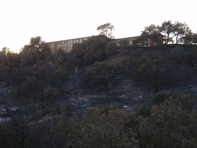
Parma Overview from W. Mtn Dr.(Permission to enter this area by SBPD)


West Mountain Drive


Parma Trails


Parma Fire Road


Parma Hillsides and above W Mountain

Picnic area still standing!

Cold Springs Trail- Of the three trails affected, Cold Springs had the least amount of damage. The fire primarily stayed to the west of Cold Springs Cyn due to the winds and from the help of fire fighters. The lower part of CS Trail up to just past the West Fork seemed to be the only affected areas. At the time that the photos were taken the West Fork was still closed.

Cold Springs Trail Head(west side of creek)

Cold Springs Main Trail where the fire stopped

Phos-Chek coated sign at the juncion

Phos-Chek coated rocks in the creek from aircraft

Warning at the W Fork

Tea Gardens

Hillside above West Fork(note- the fire did not continue up towards Tangerine Falls or the trail to Gibralter)

Rattlesnake Canyon Trail- The Lower part of Rattlesnake was burnt up pretty good. The fire burnt down the hill from the monastary up to St Marys Seminary and down the canyon a few hundred more yards. For about 1/4 of a mile the trail is burnt on both sides really leaving the trail in a unrecognizable state. From that point up until the next creek crossing the fire primarily stayed on the east side above the trail. It does not appear that there is much if any damage past the second creek crossing except on upper hillsides. This trail is closed at the time of this posting.

Rattlesnake Trail Head

St Marys Seminary

Rattlesnake Trail(photo taken from adjacent property)


Fire Fighters still working hot spots in RS and Skofield Park