

Parma Overview from W. Mtn Dr.(Permission to enter this area by SBPD)

West Mountain Drive

Parma Trails

Parma Fire Road

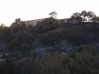
Parma Hillsides and above W Mountain

Picnic area still standing!

Cold Springs Trail- Of the three trails affected, Cold Springs had the least amount of damage. The fire primarily stayed to the west of Cold Springs Cyn due to the winds and from the help of fire fighters. The lower part of CS Trail up to just past the West Fork seemed to be the only affected areas. At the time that the photos were taken the West Fork was still closed.
Cold Springs Trail Head(west side of creek)

Cold Springs Main Trail where the fire stopped

Phos-Chek coated sign at the juncion

Phos-Chek coated rocks in the creek from aircraft

Warning at the W Fork

Tea Gardens

Hillside above West Fork(note- the fire did not continue up towards Tangerine Falls or the trail to Gibralter)

Rattlesnake Canyon Trail- The Lower part of Rattlesnake was burnt up pretty good. The fire burnt down the hill from the monastary up to St Marys Seminary and down the canyon a few hundred more yards. For about 1/4 of a mile the trail is burnt on both sides really leaving the trail in a unrecognizable state. From that point up until the next creek crossing the fire primarily stayed on the east side above the trail. It does not appear that there is much if any damage past the second creek crossing except on upper hillsides. This trail is closed at the time of this posting.
Rattlesnake Trail Head

St Marys Seminary
Rattlesnake Trail(photo taken from adjacent property)

Fire Fighters still working hot spots in RS and Skofield Park
No comments:
Post a Comment